Professional Drone Services for Precision Reality Capture Aerial Data • LiDAR • Thermal Inspections • Integrated 3D Models
Dream it
Professional Drone Services for Precision Reality Capture Aerial Data • LiDAR • Thermal Inspections • Integrated 3D Models Dream it
Introduction
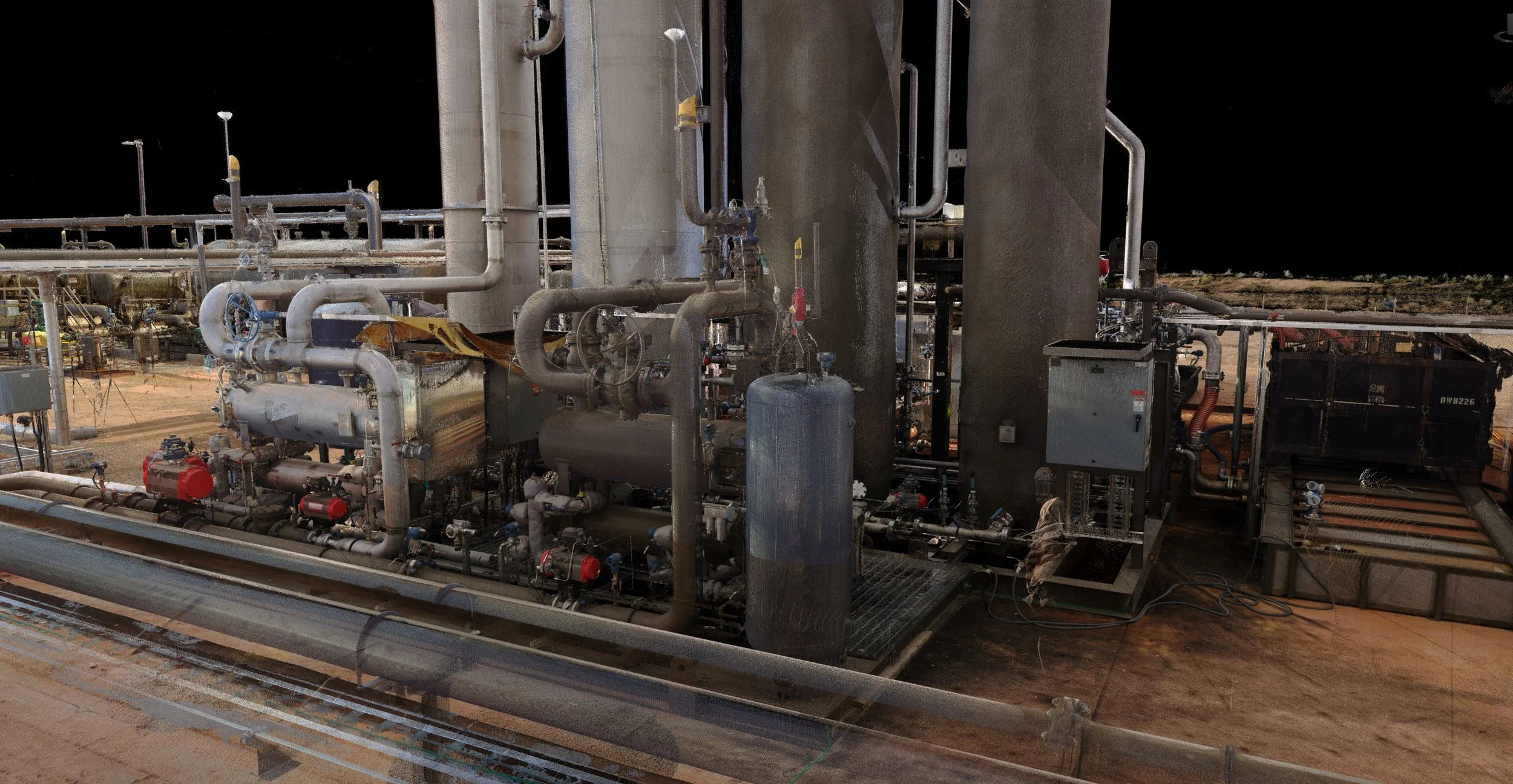
Facility Capture delivers high-accuracy drone data that integrates seamlessly with our terrestrial 3D laser scanning and drafting services. Whether you need rapid site documentation, detailed topographic mapping, thermal inspections, or rich 3D models for design and construction, our FAA Part 107 certified team provides actionable intelligence that saves time and reduces risk on complex projects.
Our mobile command center allows on-site data processing and same-day or next-day turnaround when projects demand speed — a major advantage for oil & gas, construction, and industrial clients across Texas.
Industries & Applications
Oil & Gas / Energy Existing conditions documentation, tie-in point verification, facility as-builts, pipeline corridor mapping, and thermal inspections.
Construction & EPC Site surveys, earthwork volume tracking, progress monitoring, and BIM-ready 3D models.
Industrial Facilities Tank inspections, structural documentation, safety and maintenance planning, and thermal anomaly detection.
Utilities & Infrastructure Power line and substation inspections, corridor mapping, and asset condition assessment.
Real Estate, Architectural & Remodeling Accurate existing-conditions capture for renovation projects, site planning, and marketing visualizations.
Environmental & Land Development Topographic surveys, drainage analysis, and site documentation for permitting and planning.
Solar Inspections Thermal and RGB comprehensive and standard inspections.
Our Drone Services
We combine advanced drone platforms with professional processing workflows to deliver reliable, survey-grade results.
Aerial Photogrammetry & 3D Modeling High-resolution imagery processed into accurate 3D point clouds, meshes, and textured models. Ideal for as-builts, progress documentation, and visual project records.
LiDAR Mapping & Surveying Dense point cloud capture for topographic surveys, volume calculations, contour generation, and detailed site modeling — even in vegetated or complex terrain.
Thermal & RGB Inspections Identify hot spots, leaks, insulation issues, or equipment anomalies with radiometric thermal imagery paired with high-resolution RGB data. Excellent for facilities, pipelines, power infrastructure, and tank inspections.
Plot Plans, Orthomosaics & Topographic Deliverables Accurate orthomosaic maps, digital elevation models (DEMs), contours, and plot plans ready for engineering and permitting use.
Construction Progress Monitoring & Volume Analysis Regular flights to track earthwork, material stockpiles, and construction progress with quantifiable data and visual reports.
Integrated Reality Capture Drone data combined with ground-based FARO laser scans for complete digital twins and highly accurate existing-conditions documentation.
Our Process
Consultation & Planning — We discuss project goals, site access, deliverables, and timeline.
Flight Planning & Safety — Detailed mission planning with airspace review and risk assessment.
Data Capture — Professional flights using RTK-corrected platforms for maximum accuracy.
Processing & QA — Data processed in our mobile command center or office with rigorous quality checks.
Deliverables & Integration — Clean, well-organized files delivered in formats compatible with your workflows (Navisworks, Plant 3D, AutoCAD, Revit, Civil 3D, etc.).
Support — We’re available to answer questions or provide additional processing as needed.